



10 yıl önce


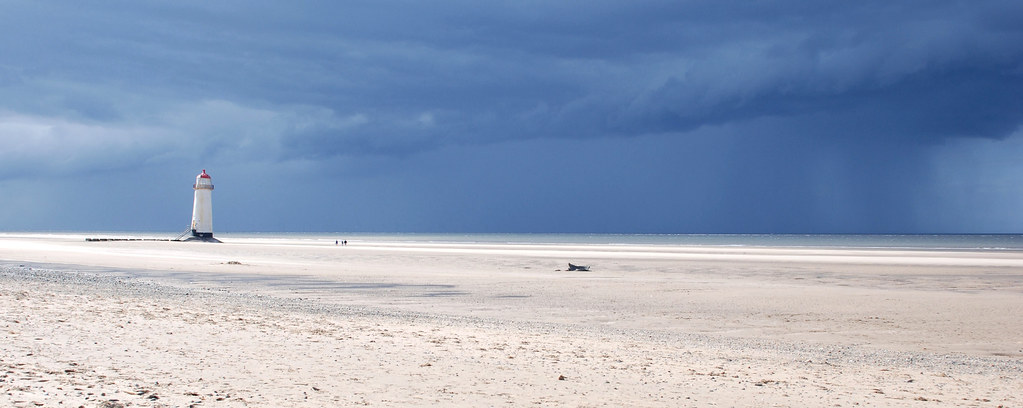
"This shot, is one of my faves, I have processed it several times, as it actually was, in Mono, and now this version. it's the Lightnouse at New Brighton in the UK. It is one of those old fashioned seaside towns, that does excellent chips, and candy floss, while you do battle with the sea gulls to keep your food. The main attraction for me was the Lighthouse though, and the long promenade. Also. watching the kids trying to catch things like crabs.
Really like the the vintage feel to the image, old postcard feel.
Love Suzi x"
New Brighton Lighthouse was originally known as Perch Rock Lighthouse, and construction began in 1827. Since 1 October 1973 it has not been in use as a lighthouse, having been superseded by modern navigational technology.

| The 17th century Beacon Tower looks to the casual onlooker like an original lighthouse structure and indeed some claim that that is what it was, built in 1673 with the permission of Charles II, who also gave permission for the collection of dues from passing ships. More credibly it is thought to be simply a beacon tower, the iron grill at the top being for bushes and wood to burn as warning at times of wartime invasion. What is believed to be the original lighthouse was built in 1806 by a local customs officer to warn of the dangers of the rocky coast, some 174 ships having foundered off the coast in the previous 36 years. The present lighthouse, a towering 92’ high and with over 3.5 million candle power is visible from the sea for some 21 miles. | |||
sea also:  | |||
| Happisburgh Lighthouse | |
|---|---|
 | |
| Location: | Happisburgh, Norfolk, England |
| Coordinates WGS-84 (GPS) | 52°49.17′N 01°32.32′E / 52.8195°N 1.53867°E |
| Year first lit: | 1791 |
| Automated: | 1929 |
| Construction: | Masonry |
| Tower shape: | round |
| Height: | 26 m (85 ft) |
| Focal Height: | 15 m |
| Current lens: | Catadioptric Fixed Lens |
| Range: | 14 nm (26 km) |
| Characteristic: | White group flashing 3 times every 30 seconds |
 Happisburgh Lighthouse is the oldest working light in East Anglia, and the only independently run lighthouse in Great Britain.
Built in 1790, orginally one of a pair - the tower is 85ft tall and the lantern is 134ft above sea level. The 'low light' which was discontinued in 1883 was 20ft lower and the pair formed leading lights marking safe passage around the southern end of the treacherous Haisborogh Sands.
 Light House aims to increase the enjoyment and understanding of technologically - based media, in particular film, video, photography and creative media and to emphasise their importance to the cultural, social and economic life of Wolverhampton, the West Midlands and further afield.
HISTORY

Today Light House inhabits larger, partly-purpose-built accommodation, is an independent company and employs the equivalent of over 30 full time staff. There are still production courses, new exhibitions, films, educational activities, conferences and events. In addition, there are two major annual festivals and a myriad of activities that develop and support the growing creative industries in the City and region. The emphasis is still on giving opportunities for active involvement for everyone. Light House has held to its original mission, increasing the enjoyment and understanding of different media forms and using them for the benefit of the people of Wolverhampton and beyond. Along the way there has been support and encouragement from very many individuals and organisations. With their continued support, Light House will play an increasingly important part in the social, cultural and economic life of the City and the wider region into the future.
LIGHT HOUSE FUNDERS
A non-profit making organisation Light House is funded and supported by Wolverhampton City Council, Learning Skills Council, Arts Council West Midlands, UK Film Council, Screen West Midlands, Advantage West Midlands, Skillset and the University of Wolverhampton.

The formation takes its name from the former fourth[4] needle-shaped pillar called Lot's Wife that used to stand in its midst until it collapsed in a storm in 1764.[5][6][7] The remaining rocks are all short and squat and not at all needle-like, but the name has stuck.
The Needles were featured on the 2005 TV programme Seven Natural Wonders as one of the wonders of the South.
from en.wikipedia.org
Position 50° 39'.70 N O1° 35,42 W
The Needles Photography Don French
© Isle of Wight Tourism

Beachy Head saw numerous shipwrecks in the 17th and early 18th centuries and a petition to erect a lighthouse started around 1691.[2] The calls were ignored for over 100 years until The Thames, an East Indiaman, crashed into the rocks of Beachy Head. The petition gained momentum with the support of a Captain of the Royal Navy and Trinity House, the official lighthouse authority, agreed to attend to the matter.[3] Having witnessed the incident himself, John 'Mad Jack' Fuller, MP for Sussex, used his influence and some of his personal wealth to fund the lighthouse construction.[4]

Coordinates: 50°44′18″N 0°12′52″E / 50.7382°N 0.2145°E
from en.wikipedia The History of Belle Toute Lighthouse

This was remitted to David Thomas Stevenson, Engineer to the Commissioners, who agreed in his report on the subject on 22 October 1867. The matter was referred to Trinity House, who wrote on 21 November 1867 to the Board of Trade recommending the proposal. Trinity House emphasised that "the Calf of Man Lights were not to be depended upon from the well known prevalence of fog on the Calf even when other high lands are clear", and that, as a result at the distance of 8 miles they were insufficient to warn vessels of their proximity to Langness. A light on the Chicken Rock would be of great assistant to Mariners navigating East, West and North of the Isle of Man.
On 6 April 1868 sanction to proceed was given by the Board of Trade. However, it was not until 6 June 1873 that the last stone of the tower was laid.
On 29 April 1873 the Board of Trade conveyed to Trinity House their statutory sanction to the proposal that "the character of the light now in course of erection as Chicken Rock should be revolving of the natural colour and attain its greatest brilliancy every half a minute and further to the requisite arrangements for throwing from the same lighthouse a red sector of the light to mark the path round Langness Point. These arrangements can be carried out either by fixing an auxiliary condensing apparatus, consisting of small holophotes at the rear of the main apparatus, in the lantern of the Lighthouse or by some other method, which the optical skill of Messrs Stevenson may advise".
There was considerable correspondence and disagreement between D T Stevenson and Trinity House regarding the proposal to show a red arc from Chicken Rock to make a track round Langness Point and to fit ten holophotes in the lightroom. Mr Stevenson argued that the red arc would be useless in hazy weather, that there would be out of superficial reflections, poor ventilation and the revolving plane would be out of centre in the Lightroom. Trinity House refuted these objections and stated difficulties could be overcome by using a larger lantern with main apparatus in centre and by using Calzo Oil instead of paraffin. Under protest the red arc and auxiliary apparatus were fitted. However, experiments were carried out which confirmed Mr Stevenson's opinions and when the Chicken Rock Light was exhibited for the first time on 1 January 1875, it was without the red auxiliary and with the use of paraffin instead of Calzo.
The Commissioners, having inspected Chicken Rock Light and the Shore Station at the Calf of Man in 1875, recommended that the shore station be removed to Port St Mary, where the boatman can crew lived.
Over and above nothing could grow in the gardens "for legions of rats".
A fog signal was added about 1890.
On the night of 23 December 1960 the lighthouse was seriously damaged internally by fire and during 1961 detailed consideration was given to the problem of the future status of the station and the provision of navigational aids generally in the area.
The proposal for a major light and fog signal on the Calf Man was included provisionally in the Engineer's new Works in September 1961 and the Commissioners subsequently agreed that the matter be referred to the Shipowners through this Advisory Committee for consideration. The Secretary of the Committee later reported a substantial majority in favour of the proposal subject to a number of conditions including the addition of a form of automatic fog on the Chicken Rock.
The light was automated in 1961.


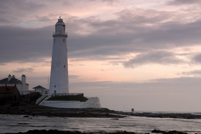
While it no longer functions as a working lighthouse, it is easily accessible (when the tide is out) and is open to visitors and has a small museum, a visitor's centre, and a cafe.
The lighthouse and adjacent keepers' cottages were built in 1898 by the John Miller company of Tynemouth, using 645 blocks of stone and 750,000 bricks. It was built on the site of a monastery where a small sanctuary light would have acted as a guide to passing ships. The lighthouse was decommissioned in 1984.






.jpg)