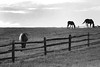
model- rammkitty-stock.deviantart.com/art/these-tattered-wings-2...
background- flickr.com/photos/piotrzurek/102719167/
thank you creative commons group for adding the above picture to the pool!
clouds- grace_stock (deviantart.com) *sorry could find the link*
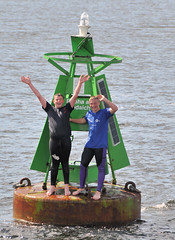
A couple of friendly locals swam out to a buoy in the Kyles of Bute to wave to the passengers on the paddle steamer Waverley.
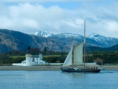
Training vessel Spirit of Fairbridge in Loch Linnhe, heading through the Corran Narrows between Nether Lochaber and Ardgour with the ebb tide.
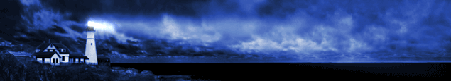
 Şile Feneri, İstanbul'un Şile ilçesinde bulunan ve
İstanbul Boğazı ile Karadeniz'e hizmet veren deniz feneridir.
Türkiye'nin en büyük, dünyanın da ikinci büyük feneri Karadeniz'deki kıyı emniyetini sağlayan iki fenerden biri olan Şile Feneri, diğer büyük fenerler gibi, Osmanlı İmparatorluğu zamanında verilen imtiyazlar sonucunda Fransız Fenerler idaresi'nce 1859 yılında yaptırılmış. Fener deniz seviyesinden 60 metre yükseklikteki kayalıklar üzerinde 110 cm. kalınlığında kule şeklinde inşa edilmiş. 20 deniz mili görüş mesafesine sahip olan, kurmal sistemli fener, ilk dönemlerde 3 fitilli gaz lambası ile çalışırken, 1968 yılında elektrikle çalışmaya başlamıştır.
Bugün müzeye çevrilen Şile Feneri'nin 150 yıllık bir geçmişi vardır..
from fotografcadisi
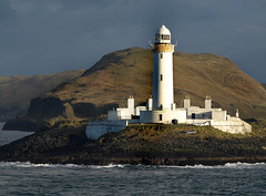
Lismore Lighthouse from the MV 'Isle of Mull' during January 2009
CoordinatesWGS-84 (GPS) 56° 27.4’N 05° 36.4’W

©Shawna Scherbarth 2001-05. All rights reserved.
Eilean Musdile is a ten-acre islet at the extreme Southern tip of Lismore island in The Firth of Lorne. The UK OS grid reference is NM 778351.
It is owned by The Commissioners for Northern Lights who purchased it in 1830 for £500
In 1833 James Smith built the facility for £4260, using a design by Robert Stevenson. The first Principal Lightkeeper, Robert Selkirk, was a descendant of Alexander Selkirk, Defoe's model for Robinson Crusoe.
After 1910, Musdile and Fidra were the sole remaining catoptric Northern lights.
Musdile was automated in June 1965.

Russian Northern coast is a vast territory lays for a few thousand of miles and all this coastline is inside the Polar Circle. Long polar winters mean no daylight at all, just one day changes another without any sign of the Sun rising above the horizon. There is only polar night for 100 day a year.
But across this Northern coast there was always a short way for the cargo boats to travel from Eastern part of Russia to the Western. Now this trip can be made fairly easy with the appearance of all the satellite navigation equipment like GPS and others, but during the Soviet Era they had none of this.
So, the Communist Party of the Soviet Union decided to build a chain of lighthouses to guide ships finding their way in the dark polar night across uninhabited shores of the Soviet Russian Empire. So it has been done and a series of such lighthouses has been erected. They had to be fully autonomous, because they were situated hundreds and hundreds miles aways from any populated areas. After reviewing different ideas on how to make them work for a years without service and any external power supply, Soviet engineers decided to implement atomic energy to power up those structures. So, special lightweight small atomic reactors were produced in limited series to be delivered to the Polar Circle lands and to be installed on the lighthouses. Those small reactors could work in the independent mode for years and didn’t require any human interference, so it was very handy in the situation like this. It was a kind of robot-lighthouse which counted itself the time of the year and the length of the daylight, turned on its lights when it was needed and sent radio signals to near by ships to warn them on their journey. It all looks like ran out the sci-fi book pages, but so they were.
Then, after the collapse of the Soviet Union, the unattended automatic lighthouses did it job for some time, but after some time they collapsed too. Mostly as a result of the hunt for the metals like copper and other stuff which were performed by the looters. They didn’t care or maybe even didn’t know the meaning of the “Radioactive Danger” sign and ignored them, breaking in and destroying the equipment. It sounds creepy but they broke into the reactors too causing all the structures to become radioactively polluted.
Those photos are from the trip to the one of such structures, the most close to the populated areas of the Russian far east. Now, there are signs “RADIOACTIVITY” written with big white letters on the approaching paths to the structure but they don’t stop the abandoned exotics lovers.


photos by kamatoz
Coordinates:  46°29′40″N 32°13′58″E / 46.4944335°N 32.2327709°E / 46.4944335; 32.2327709
Adziogol Lighthouse (Ukrainian: Аджигольський маяк; Russian: Аджигольский маяк) is a graceful vertical lattice hyperboloid structure of steel bars, 70 meters high.
Designed by Vladimir Shukhov in 1910, it is situated in Dneprovsky Liman firth about 30 km from Kherson, Ukraine. Its light can be seen for up to 17 nautical miles (31 km).

Tiumpan Head (Scottish Gaelic:Rudha Tiompan) lighthouse in the village of Portvoller in Point, Isle of Lewis, was long promoted as an idea but refused for a long period by the Board of Trade. It was approved in May 1879 after a recommendation by the Western Highlands and Islands Commission to additionally keep a watch on illegal trawlers.
The estimated cost of the lighthouse and building was £9000. It was designed by David and Charles Stevenson, and John Aitken was the contractor. William Frew was appointed as inspector of works. Chance Brothers made the optics and the revolving machine was made by Dove and Co. The light was first exhibited on 1 December 1900. There was a complement of six lightkeepers attached to the station, three lightkeepers and their families at the station and a local assistant and two occasional lightkeepers coming in from Portnaguran village nearby.
Queen Elizabeth II along with Prince Charles and Princess Anne visited the lighthouse in 1956 when the seven year old heir to the throne sounded the first blast on a new fog siren. The fog signal was operated by compressed air supplied from a compressor, which was driven by a Kelvin Diesel Engine. There were three Kelvin engines and compressors, and when the fog signal was in operation, two of them were in service to maintain the required air pressure with one standby, in rotation.
The lighthouse was automated in 1985.
from en.wikipedia.org
Prasonisi Coordinates:  35°52′57″N 27°45′40″E / 35.8825°N 27.76111°E
 Prasonisi (also Prassoníssi) cape is a part of Rhodes island. It is located 92 km from Rhodes town; 40 km from Lindos, at the southern-west part of Rhodes.
Prasonisi is the Greek word for "green island". During summer time, and when water levels are low enough, this island is a pensinsula attached to Rhodes. During the winter time, and when water levels are high enough, Prasonisi becomes an island. The southern-most tip of Prasonisi contains a lighthouse. The closest Greek village is Kattavia; however, there is a purpose-built settlement on Prasonisi that contains motels, convenience stores, restaurants, and windsurf rentals which are open seasonally. Near Prasonisi is Vroulia, an ancient settlement that contains an old mosaic tiled floor.
from
panoramio.com


.jpg)